Reservoir Distribution and Production in Mobile Shale Basins-Examples from the Cruse Formation of Southern Trinidad
AAPG / GSTT Hedberg Research Conference “Mobile shale basins – Genesis, Evolution and Hydrocarbon Systems”, Trinidad , 4th – 7th June 2006
Production from the reservoirs of the Upper Miocene- Lower Pliocene Cruse Formation in the offshore and onshore in the Southern Basin of Trinidad appears to be related to the proximity of faults and shale diapirism.
Subsurface and outcrop examples will be used to demonstrate the effects of shale instability on the distribution and production from reservoirs deposited in mobile shale basins. Outcrop studies (Siparia Point, Anglais Point, Quinam Bay, Galpha Point and Morne Diablo Bay) indicate the Cruse shales were deposited on an unstable prodelta setting, with subsequent rapid deposition of deltaic sands. This paper will seek to examine if there is a relationship between shale diapirism, reservoir continuity and productivity in the onshore Trinidad area.

Location map

Fig.2 Stratigraphic chart for the Trinidad area.
The Cruse Formation (Fig 2 ) was first defined by Macready (1921), Suter in 1951 summarised what represents the accepted pre¬sent usage of the term Cruse Formation, the thickness of which varies and may exceed 5000 feet in the Erin Syncline of south west Trinidad. The lower boundary is transitional to the Lengua Formation, while the upper boundary is locally strongly unconformable to the Forest Formation. It has been subdivided into an Upper, Middle and Lower member based on sand content and paleontology. The Lower Cruse is dominantly clayey, with individual sands over 100 feet thick. The Middle and Upper Cruse are generally sandy and in some areas sands are laterally continuous.

Table 1– Foraminiferal assemblages used to identify the Morne L’Enfer, Forest and Cruse Formations and their bathymetries.
Various foraminifera assemblages (Table 1 ) have been used to define the Cruse and other formations and at the same time place them into a paleo bathymetric framework. Work by the Geological Services Lab at Petrotrin has indicated that the Upper and Middle Cruse is dominantly inner neritic to marginal marine, while the Lower Cruse is lower slope to bathyal in depth. The Cruse Formation and the correlative Middle – Lower Gros Morne formation of eastern Trinidad, and Pedernales and Amacuro Members of the La Pica Formation from Venezuela extends from onshore Venezuela through the Gulf of Paria and onshore Trinidad (Fig.3 ) into the offshore Columbus Basin in the subsurface.

Fig.3 Map of Southern Trinidad showing the distribution of outcrops of the Upper and Middle/Lower Cruse Formation and their correlative equivalents.
In the past, a rigid adherence to the use formaninferal assemblages has led to errors in identifying the formations. For example in areas near the Brighton/Vance River/Guapo Highs, the Cruse is strongly unconformable on either the Brasso/Nariva/Cipero/Navet Formations. The Cruse sediments show a strongly heterogeneous foraminiferal faunal assemblage that was interpreted as either an older formation or as mudflow deposits. It however, reflects the input of the eroded and reworked older sediments into the Cruse. 3D seismic data within the Trinmar lease in the southern Gulf of Paria confirms the latter interpretation.

Fig.4 Map of Southern Trinidad showing the distribution of mud volcanoes and oil fields.
In the literature, there has been described an association between hydrocarbon accumulations and mud volcanism. Nowhere is this better seen than around the Caspian Sea / Baku area. Fig.4 shows the location of oilfields in the southern half of Trinidad and Gulf of Paria. There is a weak correlation between the location of mud volcanoes and oil fields, however the mud volcanoes are more commonly located near the Los Bajos Fault and major thrust faults. In both the onshore and offshore the crest of the Southern Anticline is marked by several active mud volcanoes.

Fig5. – Surface geological map (1:25000) of the Morne Diablo area, after Kugler (1959) and Barr (1940)
The major structural features of the Morne Diablo area (Fig.5 Morne Diablo Kugler map) are (1) the Los Bajos Fault, which according to Wilson (1965) is a right lateral strike slip fault with 7 ½ miles displacement (2) the ENE-WSW trending Southern Anticline and (3) The Morne Diablo, Landorf and L’Eau Michele Mud volcanoes. The proximity of the mud volcanoes to the Los Bajos Fault (LBF) has traditionally led to the conclusion that they were formed by mud mobilized along the LBF fault plane. They are however, more closely associated with the crest of the Rock Dome uplift and its associated thrusts, especially where they intersect the LBF. The small vent identified by Higgins and Saunders (1974) near the beach is not known to active at this time.
Outcrops of the Upper – Middle Cruse Formation along a four mile stretch of Morne Diablo Bay were studied. These outcrops were dominated by highly deformed claystones and sandstones, and in places these with claystones, siltstones and sandstones were well bedded. Two wells drilled inland also penetrated a claystone dominated sequence with rare thin (10’) sands. Previous workers have suggested these deformed sediments represent mud flows or mud intruded into the country rock. The proximity of mud volcanoes appeared to validate this conclusion.

Plate 1 (Unslumped claystones) Parallel bedded claystones with minor sands. The claystones weather with a conchoidal fracture.
Closer examination of these outcrops by the authors has however revealed a different story. Three sedimentation styles / depositional environments were identified. The oldest sediments exposed comprised parallel bedded (Plate 1) siltstones/claystones and thin channelised sands.

Plate 2A-E. (A) Highly contorted and slumped claystones, the direction of overturning of the slump fold axes suggest transport of material to the east. (B) Parallel bedded claystones disturbed by underlying slump deposits. (C) Multiple slump folds in claystones. (D) Fold in claystones, also visible are load casts. (E) Totally disrupted claystone with iron stained concretions.
These are overlain by slumped and highly deformed siltstones and claystones (Plate 2 A-E )

Plate 3 (slump 670682 1113680). Large slump within claystones. Within the claystones there are 2 groups, one that is extensively slumped and the other where all bedding is planar parallel.

Plate 4(A-D shallow water sand) (A) parallel bedded sands at Siparia point, sands are separated by thin claystones (Man for scale). (B) Moulds of bivalves in sandstone. (C) Macronichnius and Thalassoinoides have intensively bioturbated the sand bed. (D) Close up of Ophiomorpha in sandstone at Siparia Point.

Plate 5 (headland at 668175 1113493) severely deformed sandstone beds, the thicker beds maintain some degree of continuity, while the thinner ones are disrupted and variable in thickness. The large knife shaped sandstone block is about 6 ft thick and appears to float in the claystones.

Plate 6 (Siparia Point looking east). From left to right is a sequence of claystones and sands, with a slumped bed separating it from the sands above. A sandstone with abundant Ophiomorpha is the last bed. As of 4-3-2004 the last sand bed has been eroded and the coast retreated by 4’, dip of the underlying sandy clays is 650, strike 930, direction of dip 1830. The paleocurrent direction is to 750.

(Fig 6A-C. Morne Diablo 1,2 &3) Measured section at Siparia Point, Morne Diablo Bay.

(Fig 6A-C. Morne Diablo 1,2 &3) Measured section at Siparia Point, Morne Diablo Bay.

(Fig 6A-C. Morne Diablo 1,2 &3) Measured section at Siparia Point, Morne Diablo Bay.
The Bonasse field near Galpha Point in south west Trinidad was discovered in 1912, however problems with production and producibility resulted in the field being shut in until recently when Trinidad Exploration and Development (TED) started a new exploration and development program. The area lies on the crest of the Southern Anticline which is the site of many mud volcanoes, both in the onshore and offshore. At Galpha Point coastal erosion has exposed a mud intrusion (Plate 7 A-D (galpha photo collection) that has deformed the surrounding Upper – Middle Cruse sands and claystones.

Plate 7A-D (galpha photo collection) (A) Photo showing a shale intrusion at Galpha Point. Upper – Middle Cruse sands and claystones on the left of the intrusion dip gently to the SW, those on the right are almost vertical. In the background a workover rig is on a nearby well. (B)– close up of the contact between the mud and bedded Cruse. Sediments along the contact zone appear to be ‘crushed’ and angular fragments of sand and claystones are floating in the mud flow. (C)– Close up of the intruded mud. Rather than a homogeneous mass it consists of discrete masses of well bedded claystones that seem to be partially imbricated and heavily fractured. (D)– Vertical fractures are common in the mud mass.
Beds are generally nearly vertical and appear to have a strike of N-S. Some of sands exposed in outcrop (Plate 8) appear to have climbing ripples suggesting that reservoirs should be continuous. All sands in the outcrop are oil impregnated and have oil and gas seeping from them.

Plate 8 – Climbing ripples in Upper-Middle Cruse sands.
On the coast numerous large rock clasts are found, an examination of them reveals sandstones and conglomerates very similar in appearance to Herrera Sandstones, fragments of Naparima Hill argillite, various limestones, sandstones, calcite layers with cone in cone structures and pyrite. Some of these exotic blocks can be very large, Kugler (1925) reported a block of Amphistegina limestone 20’ by 30’ near the Columbia Chimney. The variety of material strongly suggests that the origin of the mud has to be fairly deep in the footwall of the fold, and has risen to the surface by a combination of migration along fault planes and incorporation of the country rock through which it is rising.
Inland, as seen at Bridge B1-113 (Plate 9 ) the rocks have been deformed so they go from a dip of 200 to vertical over a distance of 3ft. This means that potential reservoirs may have been breached and thus explain why the down dip wells are wet. Deformation of this type was probably associated with the intrusion of mud.

Plate 9 Outcrop at Bridge B1-113.
Barker and Roberts (1965) in their description of the Cruse outcrops at Quinam Bay (Fig 7. ) suggested that they represented an eroded mud volcano. The prominent hill near the center of the bay was thought to the main cone, while the slumped claystones, siltstones and sands were thought to be mudflows that flowed south away from the vent. Boulders of Eocene and Oligocene material on the coast further confirmed that opinion. Higgins and Saunders (1974) also mapped a modern mud volcano inland from the beach near the crest of the Southern Anticline

Fig 7 – outcrop spot map of Quinam Bay
The Kugler (1959) geological map (Fig 7. -Kugler surface geological map) has however shown this ‘mud flow’ outcrop as Lengua Formation.

Fig 8 – Kugler surface geological map

Plate 10 A-B – tightly folded sandstones and deformed claystones exposed in the wave cut platform.
Re-examination of the outcrops show a cyclicity in depositional styles not recognized by previous workers. The ‘oldest’ rocks are made up of highly deformed and folded claystones, siltstones and sands (Plate 10 A & B) that are result of failure of the old delta front.

Plate 11A – rounded lignite clast ‘floating’ in sand bed.
Within the sands are large rounded clasts of sand and lignite (Plate 11 A & B).

Plate 11B – sandstone ‘concretion’ floating in deformed sandstones

Plate 12 – alternating parallel laminated sands and clays
The deformed deposits are overlain by parallel laminated and bedded claystones (Plate 12) that are in turn overlain by thin rippled sandstones (Plate 13).

Plate 13 – oscillation ripples cu ) top view of rippled sandstones.
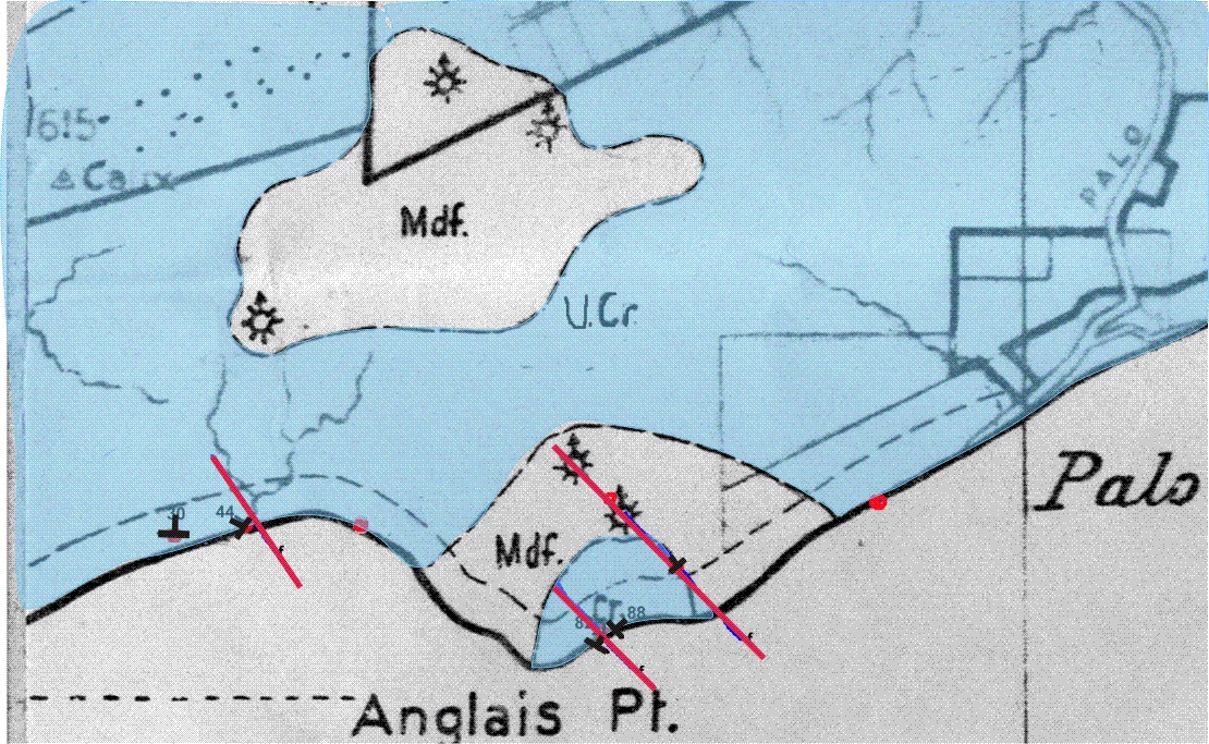
Fig.9 Spot surface geological map Palo Seco / Anglais point (After Kugler 1959)
The Palo Seco – Anglais Point area lies near the crest of the Southern Range Anticline. Downdip and to the north lies the Palo Seco field which produces oil from as shallow as 500 ft. The Kugler surface geological map (Fig.9 ) indicates that the Upper – Lower Cruse outcrops and a number of mud volcanoes exist. Nearby coastal outcrops were examined by Lackhan et al. (2005), foraminifera and pollen were recovered from samples. The forams indicated that the section lies in the N17-19 zone of L. Miocene – E. Pliocene age, Epistominella vitrea indicates a shallow water/abandonment facies, while the pollen, Dinos Symphonia, M. howardii, Mauritia and fern spores indicates a marine environment.

Plate 14 – mv cone Main mud pool at Palo Seco & Recent mud volcano cone (Gryphon)
Closer examination of the area shows that instead of a single mud volcano edifice it consists of a number of small mud pools (Plates 14 & plate 15 ) and cones oozing mud and bubbles of gas.

Plate 15 – palo seco mv pool) Main mud pool at Palo Seco & Recent mud volcano cone (Gryphon)

Plate 16 (anglais point cruse pan)- Vertically dipping Upper Cruse sands on the coast at Anglais Point
At Anglais Point (Plate 16 ) outcropping sands are either vertical or nearly so, this is probably due to the effects of the extrusion of mud at vents inland.

Plate17 view of the mud flow / slump looking south to the Columbus Channel from the Anglais Point vents.
This extrusion seems to have caused the slope to fail, with mud flow material and country rock flowing downhill (Plate 17 view of flow looking south) to the coast.

Fig 10 Schematic cross section showing the relationship between the extruded mud and the Southern Range Anticline.
In the 1940’s two wells APS-1 and 2 were drilled in the vicinity of the mud vents at Palo Seco (Fig 10- ) and their lithology is claystone dominated with minor sands.

Plate 18 (A) Parallel laminated claystone and siltstone, present are also sand starved ripples and Macaronichnus. (B) Alternating parallel bedded and laminated claystone and clay rich sands. (C) Slumped sand with iron stained nodules. (D) Alternating sub parallel claystone and sandy layers, the effects of soft sediment deformation can be seen on the right. (E) Outcrop showing lenticular channelised sand (4ft. max.) in a claystone dominated sequence. Some of these claystones downlap onto the top of the sand
This is similar to the coastal outcrops where most of the claystones are parallel laminated and individual sands range from 2-4 ft in thickness (Plate 18 ). Considerable difficulty was experienced in drilling APS-1 due to the presence of mudflows near the surface. When mud weights were raised to control the mud, circulation was lost and the well had to be abandoned.
The Forest Reserve field was discovered in 1914, as of 2006 1,668 wells have been drilled with a cumulative production in excess of 270 MMBO. A number of well have also been used as type wells for the description of the Morne L’Enfer, Forest and Cruse Formations.
FR 686 drilled in 1943 in the near crest of the Bernstein Anticline of the Forest Reserve field was the first well to encounter the mud flow. Paleontologic analysis of cuttings and e-log correlation indicated that instead of the normal Morne L’Enfer – Forest – Cruse sequence the wells went from the Forest Formation into what appeared to be Cipero Formation and back into the Cruse without encountering a Lower Forest Clay. To resolve this problem, a full hole core was taken in the mud interval of the well FR793, which confirmed that the mud was indeed of Cipero age. At least 20 wells have encountered “mud flow” material the last being FR 1629 in 2001.
The full hole core taken in FR 793 was described as non-bedded or flow bedded dark grey oil smelling clay with angular rock inclusions. Paleontologic analysis of the material indicated a dominant Lower Miocene age – Upper and Middle Cipero, with some Lengua.
Fig 11 West – East trending structural cross section illustrating the distribution of the mud flow in the sub-surface. Note that within the mud flow some wells have encountered oil bearing sands. The interval thickness between the top Forest and Top Lower Cruse is fairly uniform, suggesting that the mud was being extruded at the same time sediments were being deposited.
Fig 12 Northwest – Southeast trending structural cross section illustrating the distribution of the mud flow in the sub-surface. The interval thickness between the top Forest and Top Lower Cruse is in this case variable, with the greatest thickness being near FR-941.The Lower Cruse and Lengua sediments are structurally deeper and may be due to subsidence due to shale withdrawal from the underlying Cipero clays.
Bower (1951) first described this mud intrusion, Suter (1951b), Bower & Hunter (1968) and Higgins and Saunders (1974) later added further details about this feature. It was initially thought to be an intrusion of mud into the Cruse and Forest sediments after they were deposited, similar to a laccolith. Bower (1951 & 1968) has described the mud flow as being circular in plan view and this has been confirmed by the authors during subsurface mapping carried out in the area (Figs 11 & 12 ). Well data has indicated that the base of the mudflow is fairly flat and a domed top. A vent and ‘mud flows’ were mapped by Young (1941) on the surface in Morne L’Enfer (ML’E) sediments suggesting that there was a surface volcano during ML’E time.
It is currently felt that instead of being an intrusion this feature actually represents a buried mud volcano. It was initiated during the deposition of the Cruse, probably due to the loading of the Cipero shales by the advancing Cruse delta. Mud was erupted onto the surface/water bottom as a series of episodic flows that were buried by the ongoing sedimentation. This process was repeated until the sediments completely buried and ‘killed’ the volcano. Erosion and reworking of the mud flows into the surrounding sands has affected the reservoir quality.
Within the past 5 years a number of wells have drilled through this mud mass (using water based drilling mud) without any problems. This confirms that the system is dead and all pressure had bled off long ago.
X-Ray Diffraction analysis of a number of sands in a nearby well from the Upper-Middle Cruse interval shows that quartz makes up 61-65%, feldspars 11-13%, siderite 2 – 4%, Kaolinite 5- 7%, Mica and Illite 3% , Mixed layer Illite / Smectite 12 – 13% of the sample respectively. The clays are detrital and partially recrystallised detrital clays, with minor amounts of true authigenetic clays, suggesting that the clays may be material recycled from the mudflows.
Sediment loading is a factor leading to shale mobility.
The early Orinoco delta system produced very high basin sedimentation rates, up to 12,000’ of Pliocene – recent sediments are preserved in the Erin Syncline.
Outcrop and subsurface examples described at Morne Diablo, Palo Seco and Galpha Point illustrate deformation along an unstable shallow shelf and upper slope setting within the mobile shale province.

Fig 13a
Fig 12 a – (cruse_delta_1) shows the delta in its earliest stage of building up, with inner neritic sands and silts being deposited at the old coastlines and shelf edges. Further offshore in an inner to middle neritic setting parallel bedded claystones and silts are deposited.

Fig 13 a-d Cartoons showing the origin of slumped deposits and shallow water sediments.
With continued rapid sedimentation (Fig 13 b- cruse_delta_2) the delta front becomes oversteepened and unstable. Eventually it collapses (triggered by a storm or earthquake)
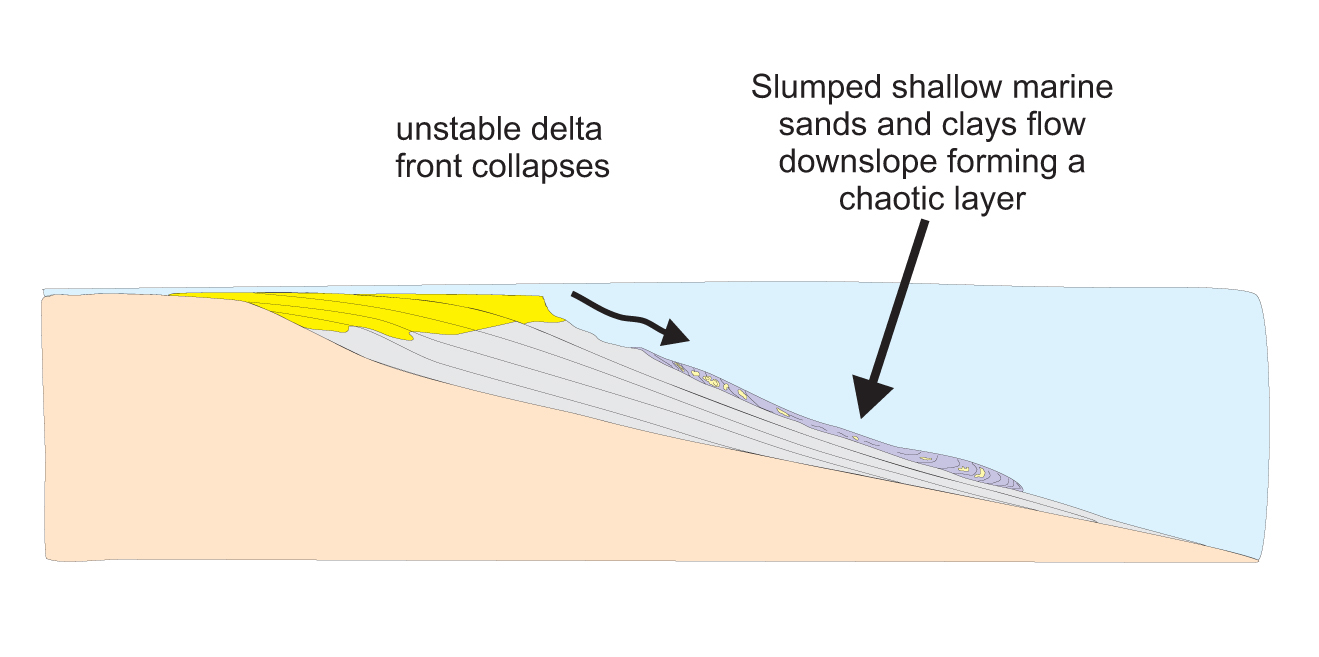
Fig 13c
(Fig 13c – cruse_delta_3) and the shallow water sands, silts and clays move downslope as slumps or debris flows forming chaotic layers. As seen in outcrop at Morne Diablo blocks of sandstone as large as 20’ by 8’ ‘float’ in these disturbed beds.

Fig 13d
Later, deposition at the re-established delta front (Fig 13d – cruse_delta_4) puts more shallow marine sands and silts on top of the slumped beds. How does this explain the erratic performance of some Cruse reservoirs? Even though the slumped beds may contain a fair amount of sand and appear as well developed sands on an electric log, lateral continuity is poor, with consequent poor production as in the Morne Diablo field south of the Los Bajos Fault (near to the Quinam Bay outcrops) and Galpha Point.
Water content of clay minerals also appears to contribute to instability with evidence of montmorillonite in samples from the Cruse Formation (Morne Diablo & Forest Reserve).
Overpressure in the Lower Cruse may be a factor not only of a high degree of sediment loading associated with rapid sediment input from the proto-Orinoco delta but also undercompaction of the L. Cruse shales.
Undercompaction does not mean no compaction, but a lesser rate of compaction on the compaction curve.
This contributes to the instability of the Lower Cruse shales deposited in a pro-delta environment; coupled with the high sediment load during progradation and deposition of the Upper and Middle Cruse deltaic sands.

Fig.14 X-Ray diffraction analysis of a claystone sample from Siparia Point. It indicates that even though the sample appears to be a claystone the quartz percentage indicates it is actually a silt.
Detailed X Ray Diffraction analysis (Fig 14. ) were performed on samples from two localities at Morne Diablo Bay, a stack at N 1114000 E 670000 (WGS84, Zone 20, Naparima Datum) and the western side of Siparia Point.

Plate 19 Stack in Morne Diablo Bay, sample locations are identified.
At the stack (slump block) two samples (Plate 19. ) were analysed, one within the slump block and the other below. The solid organic matter in the kerogen was analyzed and Sample 1 (below the slump block) had more terrestrial material – vascular and epidermal phytoclasts (epidermal and woody parts). Sample 2 (within the slump block) had notably less structured plant material and mainly comprised of gels and amorphous/structure-less material though not distinctly marine however. It must be noted that both samples had some reworked spores present but this was not quantitatively measured.
The interpretation of depositional environments based on the species identified suggests that Sample 2 was a more distal setting to Sample 1 as Sample 2 had a much greater diversity, abundance and percentage of dinoflagellate cysts as well as a notable abundance of foraminiferal test linings and the algae Pediastrum. The dinocysts observed included Polysphaeridium zoharyii, which is known to occur in lagoonal environments but also present was the dinocyst Hystrichokolpoma that is known to occur is slightly deeper settings. Sample 1 is possibly in a marginal marine setting with some marine influence with the presence of mangrove species Psilatricolporites crassus and Rhizophora in the oxidized fraction. Sands at the top of the slump block contain abundant robust Ophiomorpha.
Next to large faults, such as the Los Bajos Fault, there is problematic production. For example at Point Ligoure (C) the reservoirs tend to be initially overpressured leading to initial high production rates that tend to decline relatively quickly.

Fig 15 Map showing the location of selected Forest Reserve wells, a plan view of the mudflow near the Upper Cruse level and cumulative production of wells from the Upper/Middle Cruse interval in proximity to the mud flow.
In the Forest Reserve Field reservoirs in close proximity to shale diapirs tend to be low producers. How has the mud flow/volcano material affected the productivity of surrounding reservoirs? Anecdotal evidence from Higgins and Saunders (1974) suggested that wells in the vicinity of the mud flow were low producers, a map showing the extent of the mud flow and oil production on the Upper Cruse level (Fig 15. ) Was produced and it confirms that cumulative production does increase away from the mud flow. This may be due to mud being eroded from the sub-aerial mud volcano, and being incorporated into sands that were bring deposited in the area during Upper Cruse and Forest time. These clays have reduced permeability and thus production, they may also have reacted with the water based drilling fluids used at various time. However, a number of wells were drilled with oil based mud and show the same low production.

Fig.16 North – South structural cross section across the Southern Anticline, illustrating migration of mud along the axial plane of the fold (or fault) that gives rise to the mud volcanoes on the surface and intrusive dykes. The erratic distribution of the sand is noted in the wells and may be a combination of depositional setting and disruption by mud.
The “Upper-Middle” Cruse reservoirs are generally the best producers, a good example being the Soldado Main Field
It is unclear whether these production anomalies are due wholly to fault compartmentalization or if shale diapirism plays a role.
In the Bonasse Field many of the wells drilled near the crest of the Anticline have penetrated oil bearing reservoirs, but the highest cumulative oil production is only about 35,000 bbl. Correlation of the electric logs from the wells (Fig.16 ), has been very difficult, this and the low cumulative production suggest that reservoirs are discontinuous. It is thought that the diapirism has further compartmentalized the reservoirs. Four wells were drilled by Trinidad Exploration and Development (TED) in early 2006, each of them behaved differently while being drilled. Some required mud weights up to 16ppg within 100ft of the surface to control formation pressures. It seems that in the area the mud still retains much of its overpressure and has probably been recently emplaced.
On the coast at Anglais Point, blocks of oil impregnated sand are found along the coast indicating the presence of oil reservoirs in the subsurface. The trap for the downdip oil accumulations appears to be a lithology change from sand to claystone rather than intruded mud forming a barrier, otherwise the Cruse reservoirs would be wet like the Forest sands.
Conclusions
It is unclear whether these production anomalies are due wholly to fault compartmentalization or if shale diapirism plays a role.
Accommodation Space is a factor.
There was rapid progradation of the deltaic complex across a shallow shelf (decreased accommodation space) to the shelf margin where increased accommodation space stops the progradation of the delta and induces marked instability of the delta margin with sediment loading of the delta front.
Faults and shale diapirism appear to be a factor in production from the reservoirs of the Upper Miocene- Lower Pliocene Cruse Fm. Offshore and onshore in the Southern Basin.
This effects production from reservoirs deposited in mobile shale basins.
Shale instability leads to random distribution of reservoir sands and heterogeneities within the reservoir sands.
References
Archie, Curtis, 2002, Field Trip Guide To (a) The Upper Cruse Formation At Anglais Point, Palo Seco, (b) The Palo Seco And Anglais Point Mud Volcanoes. Geological Society of Trinidad And Tobago Field Guide, 25 p.
Archie, Curtis, 2006, Field Trip Guide to Selected Mud Volcanoes, Hedberg Research Conference – Hydrocarbon Systems in Mobile Shale Basins. Geological Society of Trinidad And Tobago Field Guide, 69 p.
Barker, M. H. S. & K. H. Roberts, 1965, Excursion 6A, South Trinidad, Transactions 4th Caribbean Geol. Conf… , P438 – 441
Bower T. H., 1951, Mudflow Occurrence In Trinidad (BWI), Bull AAPG Vol.35, No.4 P 908 – 912.
Bower T. H. & V. F., Hunter, 1968, Geology of Texaco Forest Reserve Field, Trinidad, W.I., Transactions of the 4th Caribbean Geological Conference, Trinidad P 75 – 86.
Higgins G. E. & J., Saunders, 1974, Mud Volcanoes – Their Nature And Origin., in Contributions To The Geology And Paleobiology Of The Caribbean And Adjacent Areas, Verhandlungen Der Naturforschenden Gesellschaft In Basel, Vol.84 No.1 P 101 – 152
Johnson, Nicholla, 2006, Palynology Of Two Outcrop Samples From Morne Diablo (1) Below And (2) Within Slump Block Ostolith, Internal Petrotrin Report.
Kugler, H. G. 1925, Geological Report No. 1, Report On Cedros Peninsula, Internal Petrotrin Report.
Lakhan, Christopher, Johnson, Nicholla, Archie, Curtis, Phagoo, Phillip, Charles, Desmond And Samai, Natalie, 2005, Cruse Outcrop At Palo Seco Bay, Internal Petrotrin Report.
Suter H. H., 1951b, The General And Economic Geology Of Trinidad, W.I., Colon. Geol. And Min. Res. V.2 N.3 P 177-217.
Young, R. O. 1941, Geology Of The Main Field, Forest Reserve, Internal Petrotrin Report.