
The Piparo mud volcano and its tassik on 10th September 2019
The Piparo mud volcano is located within the Naparima Fold Belt of the Central Range of Trinidad. Within the area, the Nariva Formation, a shale dominated unit (up to 3,000’ thick) with minor sands outcrops. The extruded mud contains fragments of fragments of oil impregnated sandstone, chert, fibrous calcite and other lithologies, the origin of some of which cannot be identified. The main vent is located at: E 0681020.534 N 1143191.335 (UTM, Naparima Datum), with an elevation in 2003 of 378.88 feet.


Unlike most of the other mud volcanoes in Trinidad, the Piparo mud volcano has extruded a large number of rock clasts in the mud, which cover the tassik of the cone. These clasts are made up of a number of formations which the fluidized mud has passed through on its way to the surface. Fragments of mica rich Nariva sandstone, both oil impregnated and water wet are common, lignite and parallel laminated shales are also common. Coarse Point-a-Pierre sandstones, marls similar to the Lizard Springs, Cuche Shales, chert rich material similar to the Naparima Hill Argilline, occasional greenish sandstone, red mudstones and abundant fibrous calcite occur.

View of the clast covered tassik, looking north.
Deville et al. (2002) analysed (XRD & MEB) various clasts and the mud matrix . The mud included several types of clays ( kaolinite, illite, smectite & vermiculite) other grains include quartz, feldspar, siderite, rutile, anatase, chlorite and muscovite. The mud was rich in very thin (<3mm), angular and fractured quartz grains ,this and the presence calcite crystals suggested that they were all affected by hydrofracturing.
 Examples of clasts weathered out of the mud flows


The location of the vents has remained fairly constant over the years, in spite of attempts of misguided visitors and residents to plug the vents with rubbish. The vents are also found along fairly trends the main one being roughly east – west to the north of the main vent. Other SW – NE and WNW – ESE being noted.


Chart showing the frequency of recorded eruptions at Piparo

Location of points at which changes in elevation were compared over time

Of note is that the height of the original mud volcano before the 1997 eruption was around 350 ft, the height in 2003 was 382’ with a range of 360’ – 382’, in 2004 it was 355’ – 364’ and in 2006 it was 349’ – 358’. Thus it appears that the Piparo mud volcano has lost 24’ in height, it is not known if this is due to erosion of the tassik area or deflation of the whole cone. Also note that the 2003 height indicates after the eruption it was 32’ higher mainly due to extrusion of mud. It is clear that there has been changes in elevation over time that cannot be explained by erosion alone. For subsidence along fractures on the tassik. There has been a gradual increase in height up to 2013.

WHEN WILL THE MUD VOLCANO ERUPT????
WHAT DID THE PIPARO MUD VOLCANO LOOK LIKE ON?
29th December 2020
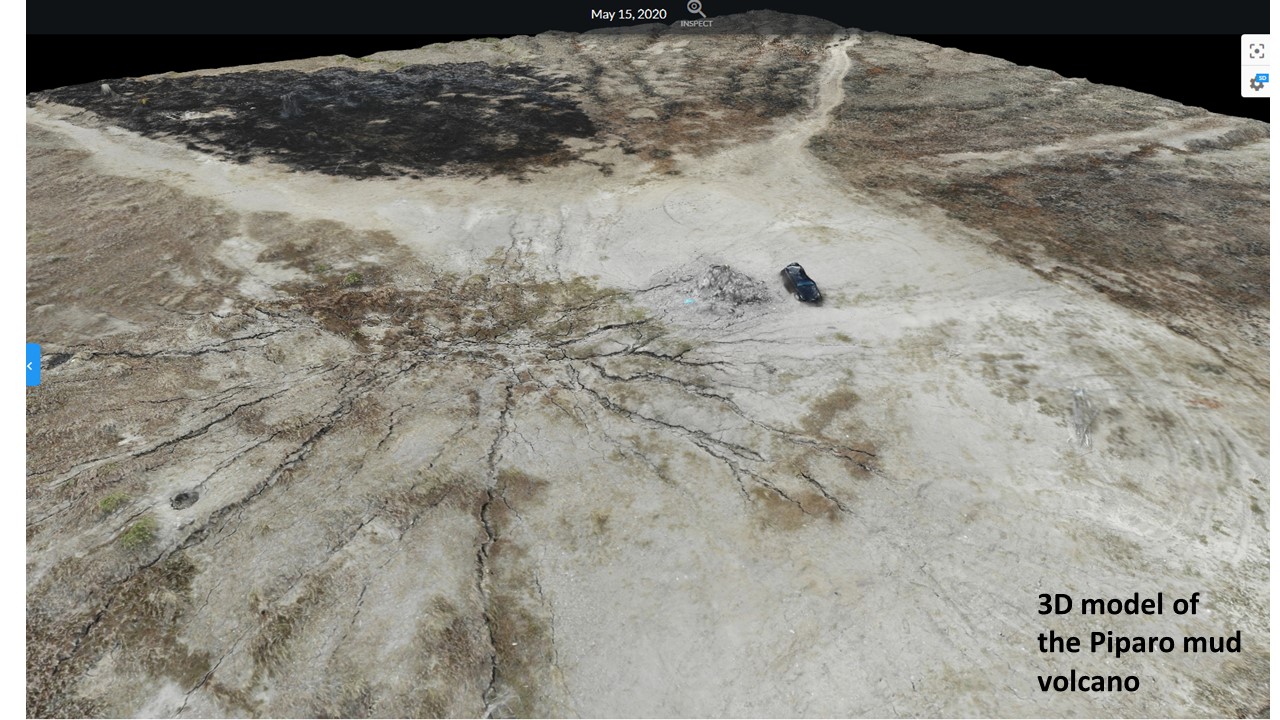
15 May 2020
13th November 2019
3rd November 2019
26th October 2019
19th October 2019
7th October 2019
28th September 2019
23rd September 2019
10th September 2019
31st August 2018
16 June 2018
17 February 2018
24 March 2013
11th February 2013
19th November 2012
12 June 2012
5th June 2012
25th March 2012
20th February 2012
15th January 2012
4th January 2012
4th December 2011
11th November 2011
THE 1997 ERUPTION

Google Earth image showing the location of the houses that were destroyed of damaged by the eruption, the two circled houses were abandoned long before .
![]()
First activity of the mud volcano occurred on 25th January 1997. NE – SW trending cracks appeared across the road. Land around the original crater was uplifted by =/- 2 feet, the road however subsided by about 2 feet. In the roadway 2 small mud cones about 1 foot high built up, but were not active when visited. Minor amounts of gas was escaping from the cracks in the road. on February 22 February 1997 the main eruption occurred and lasted about 2 minutes. Significant quantities of gas and mud were ejected and covered and area of about 1 hectare.

Photo from the Daily Express of the eruption

Panoramic view looking east on the 25 Feb. 1997

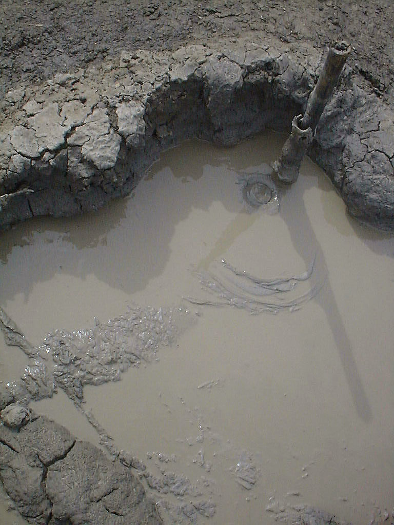
The centre of the escaping gas is marked by the stick.


Horizontal slickenslides on the south flank of the mud volcano , had a trend of . Other faults with orientations of 26 and 145 degrees (horizontal slickenslides) On the south side were also noted fractures with orientations of 105, 20 and 78 degrees – this was the most continuous and had uplift associated with it.
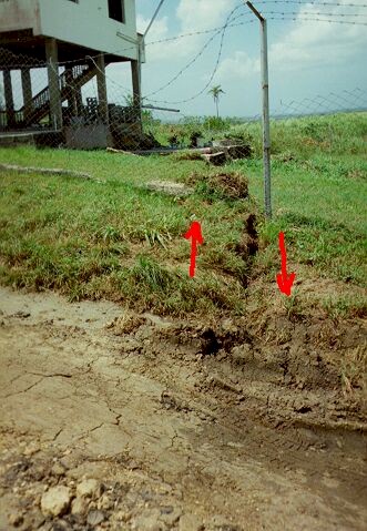
This fault had an orientation of 70 degrees, with 4 feet of left lateral motion ( south side moved west)

 View looking west, a large “Pressure Ridge” developed perpendicular to the road, it was about 3’ high. This indicates movement of material westwards, by the intrusion of material by the eruption. These pressure ridges occurred at a number of places towards the base of the hill. Not seen, but to the left of the photo is a utility pole that clearly showed movement of material west, earth was piled up on the eastern side and a large gap existed to the west. Also note the cracks parallel to the roadway. The cemetery is on the left of the photo.

 Broken wall indicating extension of the area, the crack in the wall connects to the crack in the road. Motion is to the west, down the hill.

Water filled hole in the road on the eastern side of the mud volcano. Bubbles of gas were seen escaping for at least a week.

Late 1997, Flags mark the centre of activity
2001

28 January 2001, a cone about 4’ high has developed.


2002
13 July 2002, cone has been partially destroyed by vandals. Only about 2.5 ‘ high. A pool 3’ in diameter exists. Activity is minimal with a large gas and mud bubble every 5 minutes.


2003

Main vent 26 March 2003

2006

The main vent in 18 February 2006, a smaller more active cone has developed to the north east.

18 February 2006


18 February 2006,

8th June 2006
 16 August 2006,view of the main cone and second cone

16 August 2006

16 August 2006 main cone

16 August 2006
2008

13 May 2008
2011

5 February 2011

5 February 2011
